China - Geography
China - Geography
China is the 3rd largest country in the world after Russia and Canada.
It has a great physical diversity. The eastern plains and the southern coasts of the country are fertile lowlands and foothills and is the location of mos of China's agricultural output and human population.
The area to the south of Yangtze river consists of hilly and mountainous terrain. The west and north of the country are dominated by sunken basins of Gobi and Taklamakan desert, rolling plateaus and towering massifs.
China has a long coastline of 18000 kms which is now used for export oriented trade.
Borders :-
China shares its border with 14 countries
- Russia and Mongolia to the north
- Kazakhstan to north-west
- North Korea to north-east
- Kyrgyzstan and Tajikistan to west
- Pakistan and Afghanistan to south-west
- India, Nepal, Bhutan, Myanmar, Laos and Vietnam to south
- To the east of China lies Yellow Sea, East China Sea, South China Sea and Korean Bay
Physical Geography :-
The topography of China can be divided into 5 major homogeneous region.
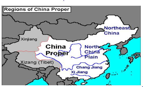
- North East Plains
- North Plains
- South Hills - the region with Chang Jiang and Xi Jiang rivers in the map
- Xinjiang - Mongolia
- Tibetan Highlands
The mountains hills and plateaus occupy about 70% of the country's land. Whereas most of the country's population is settled in the remaining 30% area comprising of lowland deserts and basins.
North - East Plains :-
The North-East plains of China are also known as 'Manchurian Plains' and they lie between Greater & Lesser Khingan mountains and Changbai mountains. Covering about 350,000 sq.km , the north east plains are the largest plains in China.
Songhua, Nen and Liao rivers flow through its vast fertile lands.
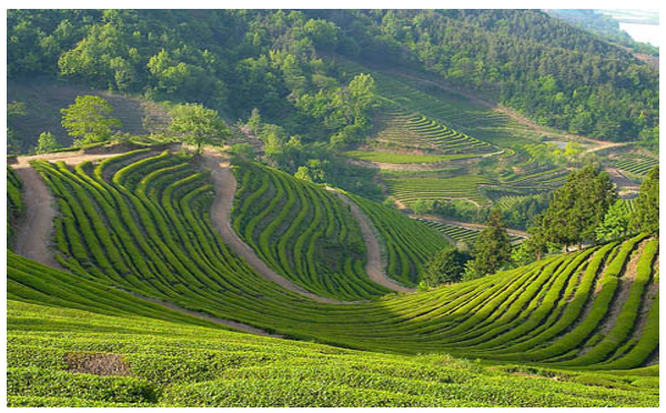
This region is suitable for mechanized farming and huge areas are planted with wheat, corn, soybean,
rice, sugar beet and sun flower.
North China Plains :-
This is a triangular region formed by the Yangtze river, Taihung Mountains and the Pacific coast.
These alluvial plains are fed by Yellow and Yangtze rivers and is one of the most populated regions in the country.
The plain is China's most important agricultural regions, producing corn, sorghum, winter wheat, vegetables and cotton. It is nicknamed as "Land of the Yellow Earth".

South Hills :-
This is a region of small mountains with an altitude ranging from 1000m to 3000m. It spans from east of Tibetan Plateau to Sichuan Basin. The floor basin has an average elevation of about 500m and is one of the most densely farmed and populated regions of China. There are several mountain ranges in this region like Kunlun, Qinling, Dabashan, Wuling, Wuyi etc.
To the south of the Sichuan basin is the Yunnan-Guizhou plateau which is known for its limestone karst landscape.

Xinjiang - Mongolia :-
North-west of the Tibetan plateau lies the Tarim Basin of Xinjiang, which consists of the Taklamakan Desert. It is one of the hottest places in China with temperatures reaching almost 50oC. Further north is Xinjiang's second great basin, the Junggar basin, which consists of the Gobi Desert. The Junggar basin is enclosed by Altay Mountains which seperates the Xinjiang from Russia and Mongolia.
To the North-east of the Tibetan plateau, is the Altun Shan - Qilian Mountain range, which are branches of Kunlun. Further north from here is the Inner-Mongolian plateau.
Between the Qinling mountains and the Inner Mongolian plateau is he Loess Plateau. It gets its name because of the loose ,yellowish soil called Loess. The Yellow river flows through this region. The eroded silt from this region gives Yellow river its color and name.

Tibetan Highlands :-
This region comprises of the tallest mountains in the world, namely the Himalayas, Karakorum, Pamirs and Tain Shan which divide China from South and Central Asia. 11 of the 17 tallest peaks in the world are in this region. This includes Mt Everest (8848 m) and K2 (8611 m).
North of Himalayas and the east of Karakorum is the Tibetan plateau, the largest plateau in the world, also known as the 'Roof of the World'. The plateau occupies almost one fifth of China's landmass.

Yellow river is the 2nd largest river in China and originates in Bayan Har Mountain in Qinghai province. Its length is 5,464 kms. It gets its typical color and hence its name due to the yellowish, loose silt called Loess, which it erodes as it flows through Loess Plateau.
The other major rivers in China are Heilongjiang, Yarlung Zangbo, Peal, Huaihe, Songhuajiang and Liaohe.
Major Provinces in China :-
Most of the country is broken down into provinces. But there are several other geographical units as the same rank as province which are as below:-
Municipality -
It is a higher level of city, directly under control of Chinese Government.
Autonomous Region -
It is a region with higher population of a particular minority group along with its own local government.
Special Administrative Province(SAR) -
This is a highly autonomous and self-governing sub national subject of the People's Republic of China that is directly under the Central Peoples's Government.
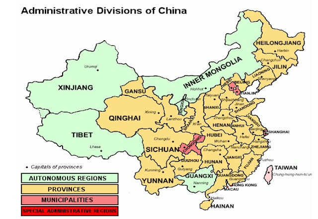
Provinces and their Capitals :-
Municipalities
This is a triangular region formed by the Yangtze river, Taihung Mountains and the Pacific coast.
These alluvial plains are fed by Yellow and Yangtze rivers and is one of the most populated regions in the country.
The plain is China's most important agricultural regions, producing corn, sorghum, winter wheat, vegetables and cotton. It is nicknamed as "Land of the Yellow Earth".

South Hills :-
This is a region of small mountains with an altitude ranging from 1000m to 3000m. It spans from east of Tibetan Plateau to Sichuan Basin. The floor basin has an average elevation of about 500m and is one of the most densely farmed and populated regions of China. There are several mountain ranges in this region like Kunlun, Qinling, Dabashan, Wuling, Wuyi etc.
To the south of the Sichuan basin is the Yunnan-Guizhou plateau which is known for its limestone karst landscape.

Xinjiang - Mongolia :-
North-west of the Tibetan plateau lies the Tarim Basin of Xinjiang, which consists of the Taklamakan Desert. It is one of the hottest places in China with temperatures reaching almost 50oC. Further north is Xinjiang's second great basin, the Junggar basin, which consists of the Gobi Desert. The Junggar basin is enclosed by Altay Mountains which seperates the Xinjiang from Russia and Mongolia.
To the North-east of the Tibetan plateau, is the Altun Shan - Qilian Mountain range, which are branches of Kunlun. Further north from here is the Inner-Mongolian plateau.
Between the Qinling mountains and the Inner Mongolian plateau is he Loess Plateau. It gets its name because of the loose ,yellowish soil called Loess. The Yellow river flows through this region. The eroded silt from this region gives Yellow river its color and name.

Tibetan Highlands :-
This region comprises of the tallest mountains in the world, namely the Himalayas, Karakorum, Pamirs and Tain Shan which divide China from South and Central Asia. 11 of the 17 tallest peaks in the world are in this region. This includes Mt Everest (8848 m) and K2 (8611 m).
North of Himalayas and the east of Karakorum is the Tibetan plateau, the largest plateau in the world, also known as the 'Roof of the World'. The plateau occupies almost one fifth of China's landmass.

Rivers
:-
China has around 50,000 rivers, each with a catchment area greater than 1000 km2.
Yangtze is the longest river in China and the 3rd longest river in the world after Nile and Amazon.
It flows for 6,300 kms across 11 provinces before emptying in East China Sea. It is also the major artery of inland transportation in China.
Yangtze is the longest river in China and the 3rd longest river in the world after Nile and Amazon.
It flows for 6,300 kms across 11 provinces before emptying in East China Sea. It is also the major artery of inland transportation in China.
Yellow river is the 2nd largest river in China and originates in Bayan Har Mountain in Qinghai province. Its length is 5,464 kms. It gets its typical color and hence its name due to the yellowish, loose silt called Loess, which it erodes as it flows through Loess Plateau.
The other major rivers in China are Heilongjiang, Yarlung Zangbo, Peal, Huaihe, Songhuajiang and Liaohe.
Major Provinces in China :-
Most of the country is broken down into provinces. But there are several other geographical units as the same rank as province which are as below:-
Municipality -
It is a higher level of city, directly under control of Chinese Government.
Autonomous Region -
It is a region with higher population of a particular minority group along with its own local government.
Special Administrative Province(SAR) -
This is a highly autonomous and self-governing sub national subject of the People's Republic of China that is directly under the Central Peoples's Government.

Provinces and their Capitals :-
Municipalities
Province
|
Capital
|
Beijing Municipality
|
Beijing
|
Chongqing Municipality
|
Chongqing
|
Shanghai Municipality
|
Shanghai
|
Tianjin Municipality
|
Tianjin
|
Provinces and Capitals
| Province | Capital |
| Anhui | Hefei |
| Fujian | Fuzhou |
| Gansu | Lanzhou |
| Guangdong | Guangzhou |
| Guizhou | Guiyang |
| Hainan | Haikou |
| Hebei | Shijiazhuang |
| Heilongjiang | Harbin |
| Henan | Zhengzhou |
| Hubei | Wuhan |
| Hunan | Changsha |
| Jiangsu | Nanjing |
| Jiangxi | Nanchang |
| Jilin | Changchun |
| Liaoning | Shenyang |
| Qinghai | Xining |
| Shaanxi | Xi'an |
| Shandong | Jinan |
| Shanxi | Taiyuan |
| Sichuan | Chengdu |
| Yunnan | Kunming |
| Zhejiang | Hangzhou |
Special Administrative Region(SAR) -
Province
|
Capital
|
Hong Kong
|
Hong Kong
|
Macau
|
Macau
|
Autonomous Region -
Province
|
Capital
|
Guangxi Huang
|
Nanning
|
Inner Mongolia
|
Hahhot
|
Ningxia Hui
|
Yinchuan
|
Xinjiang Uighur
|
Urumqi
|
Tibet
|
Lhasa
|
References :-
- · http://factsanddetails.com/china/cat10/sub64/item400.html
- · http://cpcchina.chinadaily.com.cn/2013-01/09/content_16098889.htm
- · https://en.wikivoyage.org/wiki/List_of_Chinese_provinces_and_regions
- · https://en.wikipedia.org/wiki/Geography_of_China
Also See :-

Comments
Post a Comment